Catalogs and Archives
Name Resolver
DS9 includes an astronomical name resolver connected to the display, using external name servers. Supported nameservers are ned-sao (NED@SAO), ned-cds (NED@CDS), simbad-sao (SIMBAD@SAO), simbad-cds (SIMBAD@CDS), vizier-sao (VIZIER@SAO) and vizier-cds (VIZIER@CDS).
| Command: | - |
| Menu: | Edit - Preferences - Name Server - Default |
| Description: | Sets the default nameserver prior to startup. |
| Command: | nameserver open |
| Menu: | Analysis - Name Resolution |
| Description: | Puts up the Name Resolution dialog window. |
| Command: | nameserver close |
| Menu: | Analysis - Name Resolution - Close |
| Description: | Closes the Name Resolution dialog window. |
| Command: | nameserver server [nameserver] |
| Menu: | Analysis - Name Resolution - Name Server - [nameserver] |
| Description: | Allows the name server to be selected. NED, SIMBAD andVizier servers at both CDS and SAO are supported; SIMBAD at CDS is the default. |
| Command: | nameserver name [name] |
| Menu: | Analysis - Name Resolution - Object - [name] |
| Description: | Supplies a name for nameserver search. For the GUI, must be followed by a Retrieve |
| Command: | - |
| Menu: | Analysis - Name Resolution - Retrieve |
| Description: | Sends the current name to the name resolver and fills in the FK5 RA,Dec coordinates in the Name Resolution dialog. |
| Command: | nameserver skyformat sexagesimal|degrees |
| Menu: | Analysis - Name Resolution - fk5 - sexagesimal|degrees |
| Description: | Selects the format of the returned coordinates in the dialog. |
| Command: | nameserver pan |
| Menu: | Analysis - Name Resolution - File - Pan To |
| Description: | Centers the image on the coordinates returned by the nameserver. |
| Command: | nameserver crosshair |
| Menu: | Analysis - Name Resolution - File - Crosshair To |
| Description: | Puts up a crosshair initially centered on the coordinates;the crosshair can then be moved. |
Image Servers
The Analysis - Image Servers dialog allows the user to retrieve an image centered on a given location from the selected image server. By default the location is the current image center but a dialog allows the user to change the values of the object location and the size of the retrieved image. By default the retrieved image is displayed in a new frame.
The supported servers in DS9 8.7 are DSS (hosted at SAO, ESO or STScI), 2MASS (at IPAC), VLA, NVSS and VLSS (all hosted at NRAO) and SkyView (at HEASARC).
Image Servers and surveys supported by them are as follows:
| Image server | Token | Surveys |
| IPAC 2MASS | 2mass | j, h, k |
| ESO-DSS | dsseso | DSS1, DSS2-red, DSS2-blue, DSS2-infrared |
| SAO-DSS | dsssao, dss | - |
| STSCI-DSS | dssstsci | all, poss2ukstu_red, poss2ukstu_ir, poss2ukstu_blue, |
| poss1_blue, poss1_red, quickv, phase2_gsc2, phase2_gsc1 | ||
| NVSS | nvss | - |
| VLA | vla | first, stripe82, gps |
| VLSS | vlss | - |
| SkyView | skyview | (many) |
Each image server may support multiple surveys. SkyView supports a very large number of surveys and the XPA tokens for them are not documented. SAO-DSS, NVSS and VLSS have only one survey each so no selection is needed. The STSCI-DSS 'all' option selects the best image from the combined list.
| Command: | 2mass |
| Menu: | Analysis - Image Servers - 2MASS (NASA/IPAC) |
| Description: | Sets the current image server to 2MASS. |
More generally:
| Command: | [imserver] |
| Menu: | Analysis - Image Servers - [imserver] |
| Description: | Sets the current image server. |
Once an image server is selected, we may need to specify a particular survey supported by the server, if it supports more than one. We then need to specify coordinates and a field size to retrieve an image to load into DS9.
| Command: | [imserver] open |
| Menu: | Analysis - Image Servers - [imserver] |
| Description: | Opens the image server dialog window for the given server. |
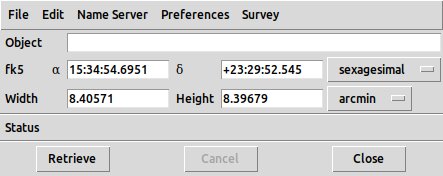
Example of image server dialog for 2MASS
| Command: | [imserver] update frame |
| Menu: | Analysis - Image Servers - [imserver] - Update from Current Frame |
| Description: | Changes the target coordinates to the center of the current frame. |
| Command: | [imserver] update crosshair |
| Menu: | Analysis - Image Servers - [imserver] - Update from Current Crosshair |
| Description: | Changes the target coordinates to the current crosshair position,if DS9 is in crosshair mode. |
| Command: | nameserver server [nameserver] |
| Menu: | Analysis - Image Servers - [imserver] - Name Server |
| Description: | Specifies the name server to use.Supported nameservers are ned-sao (NED@SAO), ned-cds (NED@CDS), simbad-sao (SIMBAD@SAO), simbad-cds (SIMBAD@CDS), vizier-sao (VIZIER@SAO)and vizier-cds (VIZIER@CDS). |
| Command: | - |
| Menu: | Analysis - Image Servers - [imserver] - Retrieve |
| Description: | Retrieves the image based on the current target coordinate and size parameters.Can only be done from the GUI. |
| Command: | - |
| Menu: | Analysis - Image Servers - [imserver] - Acknowledgement |
| Description: | brings up a text box with a suitable acknowledgement for the server.Can only be done from the GUI. |
| Command: | [imserver] name [object] |
| Menu: | Analysis - Image Servers - [imserver] - Object |
| Description: | Allows the user to enter an object name and uses the name server selected.(for GUI, user must click Retrieve) |
| Command: | [imserver] name clear |
| Menu: | Analysis - Imager Servers - [imserver] - Edit - Clear |
| Description: | Clear the selected object name in the imserver dialog. |
| Command: | [imserver] [position] |
| Menu: | Analysis - Imager Servers - [imserver] - fk5 |
| Description: | Specify the coordinates of the source directly.Either sexagesimal or decimal degree format, as previously selected.Example: 2mass 00:40:00 +42:13:02. |
| Command: | [imserver] size [width] [height] degrees|arcmin|arcsec |
| Menu: | Analysis - Imager Servers - [imserver] - Width|Height |
| Description: | Sets the field size to retrieve in arcmin. |
| Command: | [imserver] save yes|no |
| Menu: | Analysis - Image Servers - [imserver] - Preferences - Save Image on Download |
| Description: | Saves the retrieved image locally on disk. |
| Command: | [imserver] frame current|new |
| Menu: | Analysis - Image Servers - [imserver] - Preferences - New Frame/Current Frame |
| Description: | Selects whether the image ends up in thecurrent or new frame. |
| Command: | [imserver] survey [name] |
| Menu: | Analysis - Image Servers - [imserver] - Survey |
| Description: | Sets which of several surveys supported by the server is used. |
Archives
The DS9 archives command retrieves data from external archives.
There are two special cases:
- Archives - Chandra public archive by obsid takes an OBSID (e.g. 869) and displays a dialog with links to the primary data products
for that obsid. On downloading the EVT2 file, the evt2 image is displayed in a new frame.
Downloading another data product such as the ASOL file creates a new blank frame and pops up an error message.
- Archives - Chandra public archive by cone search provides a dialog which allows the user to enter an object name and a search
radius;
... File - Retrieve executes the name server and populates the dialog table with details on the selected observations.
A simple filter language is provided to select a subset of the observations. Double clicking on a row in the table then pops up
a retrieval window with links to the data products.
The remaining archives share an interface, including the Chandra CXC archive option.
- Archives - Chandra CXC, or Archives - (survey) for other values of (survey), provides a dialog with a list of observations matching the current frame location.
- Archives - (survey) - Object provides a dialog where a name can be entered (and resolved using
the selected name server at Archives - (survey) - Name Server), or coordinate values can be entered.
The coordinate values are initialized to the center of the current frame, and can be updated using
2mass update frame|crosshair,
Archives - (survey) - File - Update from Current Frame or
Archives - (survey) - File - Update from Current Crosshair.
- Once the object is resolved, Archives - (survey) - Retrieve queries the archive and returns the updated list
of observations.
- The list of observations may be printed using
Archives - (survey) - File - Print or exported to a TSV file using
Archives - (survey) - Export - Starbase or
Archives - (survey) - Export - Tab-Separated-Value.
- Click on one entry in the list to select, and use Archives - (survey) - Load to load the observation into DS9.
- Archives - (survey) - Preferences - New Frame/Current Frame controls whether the observation is loaded in a new frame
or in the current frame.
- Archives - (survey) - Preferences - Save Image on Download saves the resulting data to local disk.
- Archives - (survey) - Clear clears the current list of observations.
Catalog server search
DS9 provides support for loading, displaying, filtering, and saving catalogs. DS9 allows you to overlay symbols from multiple catalogs on the current image.
Local and on-line catalog access is supported. Most major catalogs can be retrieved from online servers. Both the CDS and SDSS catalog servers are supported. Local catalog files in starbase (rdb) or CSV (with or without header) are supported (as well as FITS and VOTable).
On-line catalogs are available via services provided by the VizieR catalog access tool, CDS, Strasbourg, France (VizieR is a joint effort of the Centre de Donnees Astronomiques de Strasbourg and ESA-ESRIN Information Systems Division) and by the Sloan Digital Sky Survey.
A selection of popular catalogs is provided in the Analysis menu. In addition, you can search for other catalogs based on title, keywords, mission, wavelength, and object type.
When a catalog is overlayed on an image, each displayed catalog symbol consists of a shape, color, and text. An advanced symbol editor is available that allows you to specify the shape, size, color, and text of each symbol, based on catalog column values. These symbol expressions can be saved for future use.
Along with the overlay display, a catalog list is provided in a separate window. It displays the column values for each catalog object. The catalog list can be sorted and filtered, and the catalog display will be automatically updated. Advanced filtering options are available. Catalogs can be loaded and saved as local files in ASCII Starbase format. Each catalog contains header information which can be displayed. The list can be printed separately from the image.
An interactive connection between the displayed catalog symbols and the catalog list is provided. When you select one or more rows within the catalog list, the corresponding symbols are highlighted on the image display. Conversely, selecting multiple symbols on the image display will highlight the corresponding rows within the catalog list. Catalog symbols can be converted to regions for use with analysis tasks.
| Command: | - |
| Menu: | Analysis - Catalogs - Search for Catalogs |
| Description: | provides a general catalog search tool. |
| Command: | catalog server [value] |
| Menu: | Analysis - Catalogs - Search for Catalogs - Catalog Server |
| GUI Default: | Edit - Preferences - Catalogs - Server |
| Description: | Select which catalog server to use. Options are cds (default), adac, sao, inasan, iucaa, bejing, saao. |
| Command: | - |
| Menu: | - Search for Catalogs - Name or Designation |
| Description: | allows you to enter an object name. |
| Command: | - |
| Menu: | ... - Search for Catalogs - Retrieve |
| Description: | then generates a list of catalogs relevant to that object. |
Alternatively, the Search for Catalogs dialog provides the ability to search for catalogs by wavelength band, mission, or astronomical topic. Again, the Retrieve option will then generate the list of relevant catalogs.
| Command: | - |
| Menu: | ... Search For Catalogs - Load |
| Description: | Once the list has been generated, click on one catalog in the list and select Search for Catalogs - Load.This brings up a new window, the Catalog Source List window, with information on the relevant entries from that catalog. |
| Command: | catalog location [code] |
| Menu: | Edit - Preferences - Catalogs - IAU Location Code |
| Description: | The code is set to the default value of 500 (Geocentric).The code is used for tasks which calculate which near field objects are in the field of an image. Currentlythe only such case is Skybot, which is no longer working. |
The user may create several Catalog Source List windows with entries from different catalogs. A new window may be created with
| Command: | catalog new |
| Menu: | Analysis - Catalog Tool |
| Description: | Brings up a new Catalog Tool window. |
This allows you to load a previously saved catalog xml file. Otherwise you won't normally bring up this window directly, it will come up from a catalog search in the Analysis - Catalogs menus.
For example, you can directly load a source list from a specific catalog with sources that match the current image location, e.g.
| Command: | catalog 2mass |
| Menu: | Analysis - Catalogs - Infrared - 2MASS Point Sources |
| Description: | Open a source catalog list window (also called the Catalog Tool window),and displaysource circles on the image, for sources from the 2MASS catalog in the current field. |
More generally:
| Command: | catalog [name] |
| Menu: | Analyis - Catalogs - |
| Description: | Open the named catalog. |
Supported catalog tokens for the CL are: ned, simbad, denis, skybot, aavos, ac, ascss, cmc, gaia, gsc1, gsc2, gsc3, nomad, ppmx, sao, sdss5, sdss6, sdss7, sdss8, sdss9, tycho, ua2, ub1, ucac2, ucac2sup, ucac3, ucac4, urat1, 2mass, iras, csc, xmm, rosat, first, nvss, chandralog, cfhtlog, esolog, stlog, xmmlog.
Also supported are
| Command: | catalog cds [name] |
| Menu: | - |
| Description: | Open the named CDS catalog. Example: catalog cds 2mass. |
and
| Command: | catalog cds [id] |
| Menu: | - |
| Description: | Open the CDS catalog with the given Vizier catalog ID. Example: catalog cds {I/252}. |
The Catalog Tool window has (see image):
- A catalog description pane, giving the name of the catalog and identifying information from the catalog server.
- An object pane, giving the coordinates and optionally a user-entered object name, and a search radius.
- A table header pane, giving a filter text box, the option to sort on a table column, a box to specify the max number of rows retrieved, an indication of the actual number of rows found, and an interface to specify which columns in the table are the RA, Dec columns - usually prefilled with the correct values using IVOA UCD metadata.
- A source list table with the actual source data, where each row is
a source from the catalog, and the columns depend on the catalog but
usually include at least a name and an RA,Dec pair. The RA/Dec columns
are identified using VO UCDs.
If the wrong ones are picked, the user can change the selection with dropdown menus in the table
header pane.
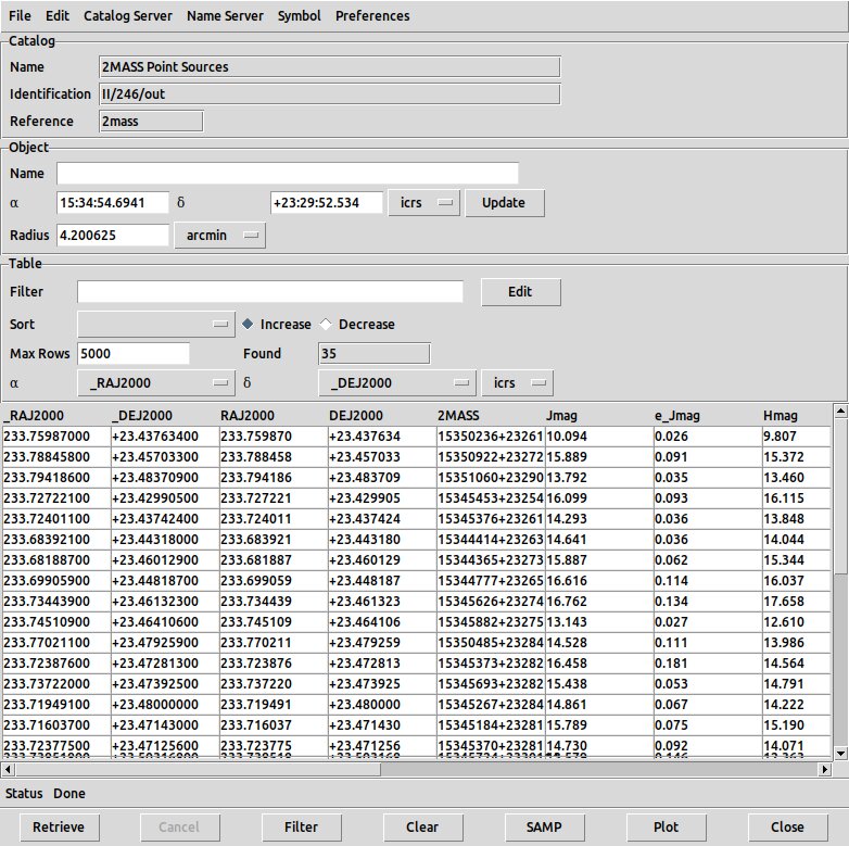
Example catalog tool with 2MASS source list
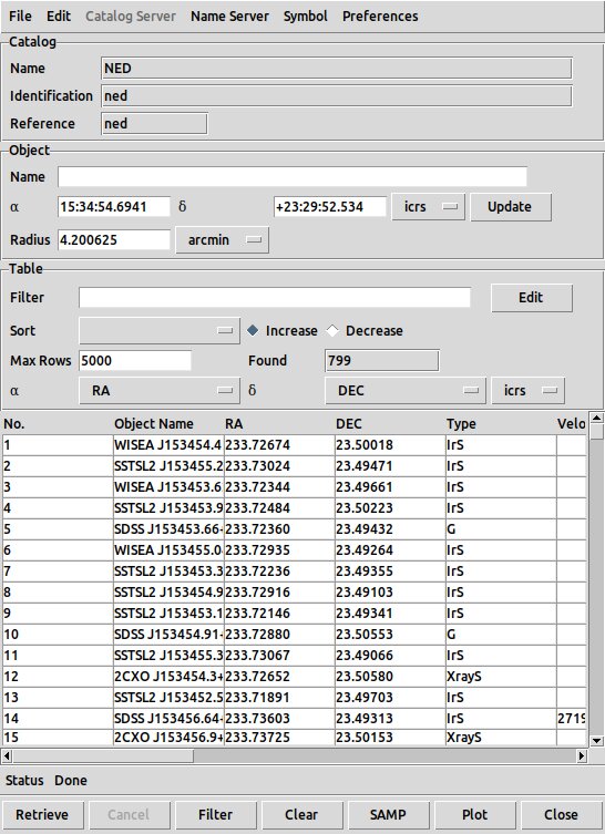
Dialog resulting from selecting NED
Corresponding NED sources displayed on image
Now the following actions are available:
| Command: | catalog retrieve |
| Menu: | Catalog Tool - Retrieve |
| Description: | Generates a new source list table given the current retrieval parameters. |
| Command: | catalog cancel |
| Menu: | Catalog Tool - Cancel |
| Description: | cancels a too-slow retrieval in process. |
| Command: | catalog clear |
| Menu: | Catalog Tool - Clear |
| Description: | Clears the table. (Note that closing the catalog tool window is notenough to cause the source circles in the display image to disappear). |
| Command: | catalog update |
| Menu: | Catalog Tool - File - Update from Current Frame |
| Description: | Changes the retrieve coordinates in the object pane to the current frame center |
| Command: | - |
| Menu: | Catalog Tool - File - Update from Current Cursor |
| Description: | Changes the retrieve coordinates in the object pane to the current cursor pos. |
| Command: | catalog sort [col] incr|decr |
| Menu: | Catalog Tool - Table - Sort |
| Description: | Sort the table. The GUI version has a dropdown menu to select a table column to sort on. |
| Command: | catalog filter [string] |
| Menu: | Catalog Tool - Table - Filter |
| Description: | Filter the table. The GUI provides a text box to enter the filter.The table may be filtered using TCL expression syntax, with column names prefixed by a dollar sign,e.g. $Jmag<14.2 |
| Command: | catalog ra [col] |
| Menu: | Catalog Tool - Table - alpha |
| Description: | Define which column in the table is the RA column. |
| Command: | catalog dec [col] |
| Menu: | Catalog Tool - Table - dec |
| Description: | Define which column in the table is the Dec column. |
| Command: | catalog print |
| Menu: | Catalog Tool - File - Print |
| Description: | Prints the table to a printer or to a text file. |
| Command: | catalog plot [xcol][ycol] [xerr][yerr] |
| Menu: | - |
| Description: | Make scatter plot of one column against another, optionally with error columns. |
| Command: | - |
| Menu: | Catalog Tool - Plot |
| Description: | This menu item will bring up a new window with a scatter plot of one table column against another.The Plot dialog allows you to define which columns to plot on the X and Y axis; the default is RA and Dec.The plot generated is a Prism Plot as described earlier. |
| Command: | catalog import rdb|tsv|fits [filename] |
| Menu: | Catalog Tool - Import - Starbase/TSV/FITS |
| Description: | Loads a source list from a Starbase, tab-sep-value or FITS-table catalog. |
| Command: | catalog export rdb|tsv [filename] |
| Menu: | Catalog Tool - Export - Starbase/TSV |
| Description: | Exports the current source list to a Starbase, or tab-sep-value file. |
| Command: | catalog save [filename] |
| Menu: | Catalog Tool - Save |
| Description: | Saves the current source list in an XML file. |
| Command: | catalog load [filename] |
| Menu: | Catalog Tool - Open |
| Description: | Opens the catalog tool and loads a previously saved XML source list. |
| Command: | catalog close |
| Menu: | Catalog Tool - Close |
| Description: | Closes the catalog tool |
| Command: | catalog current [ref] |
| Menu: | - |
| Description: | Current catalog. Used to specify which version of the Chandra source catalog to use. |
| Command: | catalog regions |
| Menu: | Catalog Tool - File - Copy to Regions |
| Description: | Copy source locations to region format. They are added to the region list in the current frame.These may then be saved to a region file with Region - Save Regions. |
| Command: | catalog samp |
| Menu: | Catalog Tool - SAMP |
| Description: | Will draw the source locations in the current frame.Once the SAMP plot has been made, if Edit - Catalog is selected,clicking on a row in the source table will highlight a source symbol(default: green circle point) in the display frame. Clicking on a sourcecircle in the display frame will highlight the corresponding row in thesource table.Mutiple rows may be selected by holding down the SHIFT or CTRL key while selecting them. |
The source list window allows controlling of various options:
| Command: | catalog coordinate [ra] [dec] [coordsys] |
| Menu: | Catalog Tool - Object - alpha,delta - Update |
| Description: | Specify the coordinates for the search center. |
| Command: | catalog name [value] |
| Menu: | Catalog Tool - Object - Name |
| Description: | Specify the name of the object whose coordinates are to be used in the catalog search. In the GUI, use Retrieve to update the table |
| Command: | catalog radius [value] degrees|arcmin|arcsec |
| Menu: | Catalog Tool - Object - Radius |
| Description: | Specify the seach radius for the catalog search. |
| Command: | catalog edit yes|no |
| Menu: | Catalog Tool - File - Edit |
| Description: | Allows you to directly edit numerical values in the cells of the source table. |
| Command: | catalog panto yes|no |
| Menu: | Catalog Tool - Preferences - Pan To |
| Description: | Selected by default. When a source is selected in the list, the image window willpan to be centered on its location. |
| Command: | catalog allrows |
| Menu: | Catalog Tool - Preferences - All Rows |
| Description: | If set, all catalog rows are available in the table. |
| Command: | catalog allcols |
| Menu: | Catalog Tool - Preferences - All Columns |
| Description: | If set, all catalog columns are available in the table, otherwise a preferred subset is shown. |
| Command: | catalog maxrows [N] |
| Menu: | Catalog Tool - Table - Max Rows |
| Description: | Set the maximum number of rows to be retrieved. |
| Command: | catalog header |
| Menu: | Catalog Tool - File - Header |
| Description: | Brings up a window with metadata describing the table columns. |
| Command: | catalog sky [coordsys] |
| Menu: | Catalog Tool - Object - [coordsys] |
| Description: | Specify coord system for retrieve. Valid tokens: fk4, b1950, j2000, icrs, galactic, ecliptic. |
| Command: | catalog psystem [wcs] |
| Menu: | Catalog Tool - Object - [coordsys] |
| Description: | Specify coord system for retrieve. Valid tokens: wcs, wcs[letter]. |
| Command: | catalog show yes|no |
| Menu: | Catalog Tool - File - Show |
| Description: | (on by default) can be used to show or hide the displayed source symbols. |
| Command: | catalog psky [coordsys] |
| Menu: | Catalog Tool - Table - [coordsys] |
| Description: | Specify coord sys for table rows. (fk4, fk5, icrs, galactic, ecliptic). |
| Command: | catalog system [wcs] |
| Menu: | Catalog Tool - Table - [coordsys] |
| Description: | Specify coord system for table. Valid tokens: wcs, wcs[letter]. |
| Command: | mode catalog |
| Menu: | Edit - Catalog |
| Description: | In catalog mode, when a catalog is loaded in the image, left clicking on a region displayedon the image that corresponds to a catalog source will highlight that entry in the catalogdialog window.Clicking on a row in the catalog dialog window will highlight that source region (in red, by default)whatever edit mode is selected. |
| Command: | - |
| Menu: | Catalog Tool - SAMP - Connect/Disconnect |
| Description: | connects and disconnects the SAMP connection. |
| Command: | - |
| Menu: | Catalog Tool - SAMP - Send |
| Description: | allows you to send the data over SAMP, either broadcasting or to a specific named DS9. |
| Command: | - |
| Menu: | Catalog Tool - File - Acknowledgment |
| Description: | brings up a window with text containing a suitable acknowledgement for usingthe catalog (however, this text may be empty). |
Catalog symbol control
| Command: | - |
| Menu: | Catalog Tool - Symbol |
| Description: | provides options to control the symbol properties plotted for the sources in DS9.If multiple catalogs are used at once for the same frame, it may be useful to use differentsymbols for each catalog. |
| Command: | - |
| Menu: | Catalog Tool - Symbol - Shape |
| GUI Default: | Edit - Preferences - Catalogs - Shape |
| Description: |
| Command: | - |
| Menu: | Catalog Tool - Symbol - Color |
| GUI Default: | Edit - Preferences - Catalogs - Color |
| Description: |
| Command: | - |
| Menu: | Catalog Tool - Symbol - Width |
| GUI Default: | Edit - Preferences - Catalogs - Width |
| Description: |
| Command: | - |
| Menu: | Catalog Tool - Symbol - Font |
| GUI Default: | Edit - Preferences - Catalogs - Font |
| Description: |
An advanced symbol editor is available that allows you to specify the shape, size, color, and text of each symbol, based on catalog column values. For each row of the catalog, one or more conditional expressions are evaluated. For the first expression to evaluate true, a given symbol is displayed, with the specified shape, color, size and text properties. As with the filter, the value of a particular column can be indicated as
$columnname
For the condition entry, the expression you type in is automatically evaluated via TCL expr after macro expansion.
    1                               # always
    0                               # never
    true                            # always
    false                           # never
    $Jmag>2                         # conditional
    sin($Jmag)>.5                   # conditional
    [string equal $Class SNR]       # conditional
    [regexp {*SNR*} $Class]         # conditional
For the size, size2, and angle entries, the expression you type in is also automatically evaluated via TCL expr after macro expansion.
    2               # value of '2' is used
    $Jmag           # value of column Jmag is used
    $Jmag/2.        # value of column Jmag div 2 is used
    (4+2)/3         # value of '2' is used
For the text portion, this is not true. It is assumed to be text, unless you explicitly use an expr operator.
    foo             # will put 'foo' above the symbol
    $Jmag           # will put the value of column Jmag above the symbol
    (4+2)/3         # will put the text '(4+2)/3' above the symbol
    [expr (4+2)/3]  # will put the text '2' above the symbol
    [expr $Jmag/2.] # will take the value of Jmag and div by 2
And finally, one special case for shape = text and text = empty. In this case, the row number is displayed.
| Command: | - |
| Menu: | Catalog Tool - Symbol - Advanced |
| Description: | pops up a symbol editor window which can define the use of different symbolsfor table entries satisfying different logical conditions. An expression editor is provided to construct the conditions.For example, if the table has a redshift column, different symbol colors can be associated with different value ranges of the redshift. |
| Command: | - |
| Menu: | Catalog Tool - Symbol - Advanced - Symbol Editor - Text - Edit |
| Description: | To add source names to the display, open the symbol editor withCatalog Tool - Symbol - Advanced,and use Symbol Editor - Text - Edit to add a column name in the Text field, thenSymbol Editor - Apply. |
| Command: | - |
| Menu: | Symbol Editor - File - Save |
| Description: | saves the current symbol definitions in a .sym file. |
| Command: | - |
| Menu: | Symbol Editor - File - Open |
| Description: | opens a previously saved file. |
Catalog Filtering
The catalog list can be sorted and filtered, and the catalog display will be automatically updated. A filter is conditional expression, when evaluated for each row of the catalog, if true, the row is displayed, and if false, the row is not displayed. The conditional expression can be any valid TCL expression. The value of a column may be indicated with $colname, for example
    $_RAJ2000>180. && $_RAJ2000<270.
    $Jmag>11
    log($Kmag*10)<.3
    [string equal $OTYPE_S SNR]
| Command: | - |
| Menu: | Catalog Tool - Table - Filter - Edit |
| Description: | pops up a dialog which helps youconstruct the filter, with Column and Operator and Math Function options.Compound expressions such as "$Jmag<14||$Jmag>16.5" are supported.Supported math functions are acos, asin, atan, atan2, ceil, cos, cosh, exp, floor,fmod, hypot, log, log10, pow, sin, sinh, sqrt, tan, tanh, abs, double, int and round.Supported operators are -, !, (, ), *, /, %, +, -, <, >, <=, >=, ==, != and &&. |
| Command: | - |
| Menu: | Catalog Tool - Filter - Edit - File - Save |
| Description: | Saves the current filter to an .flt file. |
| Command: | catalog filter load [filename] |
| Menu: | Catalog Tool - Filter - Edit - File - Open |
| Description: | Opens a .flt file containing a previously saved filter. |
Footprint Servers
| Command: | - |
| Menu: | Analysis - Footprint Servers |
| Description: | This menu allows you to select from a choiceof astronomical telescope footprint servers. For example, one may select the Chandra server.This pops up a footprint table dialog, which shows a table of observations whose footprints overlap the current image.Each row in the table gives the properties of the footprint of one observation, and the correspondingoutline of the telescope detectors is superimposed on the image (by default, in green). A pointing directionand search radius is shown at the top of the table.Clicking on a row in the table will change thecolor of the corresponding footprint outline in the image (by default, from green to red).The footprint server dialog has Object and Table panes similar to those in the catalog tool, allowing the targetposition to be modified and the table entries to be refreshed accordingly.In addition, a list of instruments is provided; one may deselect some of these and execute Retrieve to refreshthe table with only those entries |
| Command: | footprint cxc|hla |
| Menu: | Analysis - Footprint Servers - [server] |
| Description: | Calling the footprint server results in opened a window with a table of relevant observations,and corresponding observation sky coordinate footprints overplotted on the current frame.Clicking on a row in the table highlights the corresponding footprint region in the frame. |
| Command: | - |
| Menu: | Edit - Footprint Mode |
| Description: | If this mode is selected, clicking on a footprint outline in the imagewill highlight the corresponding entry in the footprint table dialog. |
| Command: | footprint retrieve |
| Menu: | Analysis - Footprint Servers - [server] - Retrieve |
| Description: | The Retrieve button updates the footprint table if changes have been made to the position and radius. |
| Command: | footprint cancel |
| Menu: | Analysis - Footprint Servers - [server] - File - Cancel |
| Description: | Cancel the (slow) retrieval currently underway. |
| Command: | footprint clear |
| Menu: | Analysis - Footprint Servers - [server] - Clear |
| Description: | Clear the footprint table |
| Command: | footprint close |
| Menu: | Analysis - Footprint Servers - [server] - Close |
| Description: | Clost the footprint server window |
| Command: | footprint name [value] |
| Menu: | Analysis - Footprint Servers - [server] - Object - name |
| Description: | Sets the name of the object which is name-resolved to a position for the next Retrieve action |
| Command: | footprint coordinate [x] [y] fk5 |
| Menu: | Analysis - Footprint Servers - [server] - Object - alpha/delta |
| Description: | Sets the position for the next Retrieve action |
| Command: | footprint sky icrs|fk5|galactic... |
| Menu: | Analysis - Footprint Servers - [server] - Object - [coordsys] |
| Description: | Sets the coordinate system for the object coordinates |
| Command: | footprint skyformat [degrees|sexagesimal] |
| Menu: | Analysis - Footprint Servers - [server] - Object - [coordsys] - Degrees/Sexagesimal |
| Description: | Sets the format for the object coordinates |
| Command: | footprint radius [value] |
| Menu: | Analysis - Footprint Servers - [server] - Object - radius |
| Description: | Sets the search radius for the next Retrieve action |
| Command: | footprint crosshair |
| Menu: | Analysis - Footprint Servers - [server] - File - Update from Current Crosshair |
| Description: | Sets the position for the next Retrieve action via the current crosshair position |
| Command: | footprint update |
| Menu: | Analysis - Footprint Servers - [server] - Object - Update |
| Description: | Update coordinates for current field |
| Command: | footprint current cxc|hla |
| Menu: | - |
| Description: | Set current footprint server |
| Command: | footprint filter [string] |
| Menu: | Analysis - Footprint Servers - [server] - Table - Filter |
| Description: | Filter the rows in the footprint table |
| Command: | footprint sort [colname] incr|decr |
| Menu: | Analysis - Footprint Servers - [server] - Table - Sort [colname] - Increase/Decrease |
| Description: | Sort the footprint table on specified column |
| Command: | footprint filter load [filename] |
| Menu: | Analysis - Footprint Servers - [server] - Table - Filter Edit - File - Open |
| Description: | Load a table filter string saved in a .flt file |
| Command: | footprint panto yes|no |
| Menu: | Analysis - Footprint Servers - [server] - Preferences - Panto |
| Description: | Pan to footprint location upon load |
| Command: | footprint save [filename] |
| Menu: | Analysis - Footprint Servers - [server] - File - Save |
| Description: | Saves the current footprint regions as an XML file |
| Command: | footprint export rdb [filename] |
| Menu: | Analysis - Footprint Servers - [server] - File - Export Starbase |
| Description: | Saves the current footprint regions as a Starbase RDB file |
| Command: | footprint export tsv [filename] |
| Menu: | Analysis - Footprint Servers - [server] - File - Export Tab-Separated-Value |
| Description: | Saves the current footprint regions as a TSV file |
| Command: | footprint print |
| Menu: | Analysis - Footprint Servers - [server] - File - Print |
| Description: | Print footprint list |
| Command: | footprint regions |
| Menu: | Analysis - Footprint Servers - [server] - File - Copy to Regions |
| Description: | Convert footprints to DS9 regions |
| Command: | footprint show yes|no |
| Menu: | Analysis - Footprint Servers - [server] - File - Show |
| Description: | Display footprint overlays or not |
VO SIA
The sia command provides support for the Virtual Observatory (VO) Simple Image Access (SIA) protocol.
| Command: | sia [archive] |
| Menu: | Analysis - Archives - [archive] |
| Description: | Select a catalog for an SIA search. Pops up a dialog box which will be filled withthe images returned by the search. |
| Command: | sia coordinate [x] [y] fk5 |
| Menu: | Analyis - [archive] - alpha/delta |
| Description: | Define SIA search position on the current catalog. Example:xpaset -p ds9 sia coordinate 202.48 47.21 fk5. |
| Command: | sia crosshair |
| Menu: | Analysis - Archives - [archive] - File - Update from Current Crosshair |
| Description: | Update the search position from the crosshair position |
| Command: | sia sky [system] |
| Menu: | Analysis - Archives - [archive] - Object - alpha/delta |
| Description: | Set coordinate system. Example: xpaset -p ds9 sia sky fk5 |
| Command: | sia skyformat [degrees|sexagesimal] |
| Menu: | Analysis - Archives - [archive] - Object - [coordsys] |
| Description: | Set coordinate system format |
| Command: | sia radius [value] [units] |
| Menu: | Analysis - Archives - [archive] - Object - Radius |
| Description: | Set SIA search radius. Example: xpaset -p ds9 sia radius 1 degrees |
| Command: | sia current [catalog] |
| Menu: | Analysis - Archives - [archive] - File - Update from Current Frame |
| Description: | Update the search position from the current position |
| Command: | sia name [value] |
| Menu: | Analysis - Archives - [archive] - Object - Name |
| Description: | Update the search position based on an object name |
| Command: | sia update |
| Menu: | - |
| Description: | Update the SIA search following changes to the search position |
| Command: | sia save [filename.xml] |
| Menu: | Analysis - Archives - [archive] - File - Save |
| Description: | Save table results of SIA search in a file |
| Command: | sia retrieve |
| Menu: | Analysis - Archives - [archive] - Retrieve |
| Description: | Execute the SIA search |
| Command: | sia cancel |
| Menu: | Analysis - Archives - [archive] - Cancel |
| Description: | Cancel SIA search in progress |
| Command: | sia clear |
| Menu: | Analysis - Archives - [archive] - Clear |
| Description: | Clear SIA search |
| Command: | sia close |
| Menu: | Analysis - Archives - [archive] - Close |
| Description: | Close SIA dialog window |